DATA AND API SOLUTIONS
AfriGIS Data Catalogue
At AfriGIS, WHERE is
where it starts!
Our passionate data scientists go beyond geography to make the connections no one else sees, and finding science-based answers that can help transform societies, people’s lives and businesses.
An organisation that understands the layers of subtleties related to their location, their footprint, where their customers are located and what those customers’ needs are, gains a stronger competitive advantage.
Whether you are in retail, logistics, telecommunications, agriculture, financial services or information technology, AfriGIS has a solution for your business needs.
For a showcase of and to experience our APIs, visit the links below.
Administrative Boundaries (South Africa)
Provinces, Municipalities, District Councils, Magisterial Districts, Wards, Tribal Authorities
These datasets show the official administrative boundaries as supplied by the Municipal Demarcation Board. A unique AfriGIS ID is added to each feature.
License: Open use
Data source: Municipal Demarcation Board
Coverage: National, i.e. Administrative area level 1-5
Feature: Polygon
Administrative (Political) Boundaries (International)
These datasets show the official administrative boundaries as determined by the University of Columbia.
License: Restricted use
Data source: University of Columbia
Coverage: International, i.e. Administrative area level 1-5
Feature: Polygon
AfriGIS National Address Database (NAD)
International standards compliant, validated and verified geospatial data.
The AfriGIS National Address Database (NAD) is a comprehensive spatial representation of physical street addresses in South Africa. The NAD not only contains the coordinates (longitude/latitude) for individual properties, but also the correct administrative features for the street address. Coordinates are generally given as the centroid of the property. The dataset adheres to national and international standards in terms of addressing and metadata.
License: Restricted use
Data source: Local Authorities
Coverage: National
Feature: Point
AfriGIS Points of Interest
(Main categories: Commercial; Topography; Human Infrastructure)
This dataset includes points of interest, including 20 main categories and over 780 sub-categories. The layer can be supplied with or without contact information. Extended option available from 3rd parties.
License: Restricted use
Data source: Multiple:
Local authorities, partnerships, research and more
Coverage: National
Feature: Point
Deeds Data
A complete transfers and bonds dataset as registered with the Department of Agriculture, Land Reform and Rural Development (DALRRD). Additional property variables derived from the Cadastre (CAD) and AfriGIS National Address Database (NAD), such as zoning and valuation can be added upon request.
License: Restricted use
Data source: DALRRD
Coverage: National
Feature: Enriched attribute data
Cadastre (CAD)
The cadastre is a register of the surveyed property boundaries in the country, as captured by the Department of Agriculture, Land Reform and Rural Development (DALRRD) around the country.
- Erven
- Farms
- Farm Portions
- Parks
- Roads
- Agricultural Holdings
License: Restricted use
Data source: DALRRD
Coverage: National
Feature: Polygon
AfriGIS Town Boundaries
This layer consists of boundaries of the historically recognised towns or municipalities aligned with the official municipal boundaries. For example, the Sandton boundary is part of the City of Johannesburg. Similar to rural areas, town boundaries for towns such as Brits and Magaliesburg are included. Custom town boundaries for well-known “unofficial” places such as the Bluff in Durban have also been created.
License: Restricted use
Data source: Multiple:
Local authorities, partnerships, research and more
Coverage: National
Feature: Polygon
AfriGIS Suburb Boundaries
This dataset includes suburb boundaries of the metropolitan, major towns and villages in the country. The associated postal codes for box and street delivery per suburb is also derived where possible.
Extensions of suburbs in larger metros are aggregated to form a complete suburb. The layer also includes well-known estates, as well as the friendly suburb name.
License: Restricted use
Data source: Multiple:
Local authorities, partnerships, research and more
Coverage: National
Feature: Polygon
AfriGIS Street Centrelines
This layer has eight categories of roads for South Africa, including highway, main, provincial, arterial and major streets for all local and metro municipalities. All major metropolitan areas in South Africa are covered. The layer is routable for navigational and logistical purposes.
License: Restricted use
Data source: National, Provincial & Local Authorities
Coverage: National
Feature: Line
AfriGIS Postal Codes
This dataset is compiled from the official postal code tables supplied by the South African Post Office (SAPO). Using this dataset in conjunction with the AfriGIS Suburb layer it is possible to map a customer dataset based on postal code. SAPO assigns postal codes according to customer demand and the layer does not provide complete coverage of the country. AfriGIS enriches the postal codes with additional variables.
License: Restricted use
Data source: SAPO
Coverage: National
Feature: Attribute table
AfriGIS Postal Code Regions
This dataset is a spatial representation of official postal code tables supplied by the South African Post Office. Suburbs with the same postal code are merged to form postal code regions. This spatial dataset includes postal region boundaries for both box and street deliveries.
License: Restricted use
Data source: AfriGIS
Coverage: National
Feature: Polygon
Census Data
The AfriGIS Census API provides users with census data per Stats SA subplace, as collated during the 2011 census.
- Age
- Dwelling
- Household Income
- Individual Income
- Employment Status
- Gender
- Land Use
- Language
- Population Group
- Water
License: Restricted use
Data source: Stats SA
Coverage: National
Feature: Attributes
AfriGIS Sectional Schemes
This layer is a register of the Sectional Schemes titles as registered at the Department of Agriculture, Land Reform and Rural Development (DALRRD). Each sectional scheme is represented as a point feature in the dataset and includes attributes like year of registration, number of counts, and more.
License: Restricted use
Data source: DALRRD
Coverage: National
Feature: Point
AfriGIS Proclaimed Town Boundaries
This layer shows the boundaries of proclaimed towns, also called townships/SG towns, as registered with the Department of Agriculture, Land Reform and Rural Development (DALRRD). This layer includes the known extensions, e.g. Eldoraigne extension 1-40 as registered.
License: Restricted use
Data source: DALRRD
Coverage: National
Feature: Polygon
AfriGIS Gated Communities
Gated Communities refer to controlled access areas. AfriGIS has extended this definition to include non-access controlled areas where residents have named their community. The AfriGIS Gated Communities data layer includes estates, sectional schemes, boomed-off areas, and commercial properties. This layer includes the number of stands and sectional scheme units in each area, as well as the associated suburb, town, municipality, and province names.
This dataset includes Gated Communities throughout South Africa. The associated street and box code is also included where available.
License: Restricted use
Data source: Multiple:
Local authorities, partnerships, research and more
Coverage: National
Feature: Polygon
AfriGIS Built Up Coverage
This dataset is a spatial representation of official built-up areas in South Africa as derived from the AfriGIS Proclaimed Towns. This layer shows the urban edge of metros and towns.
License: Restricted use
Data source: DALRRD
Coverage: National
Feature: Polygon
AfriGIS Aggregated Suburbs
This layer is based on the AfriGIS suburb layer and has been enhanced with additional attributes, e.g. census information, number of valid addresses, properties, street segments, etc.
License: Restricted use
Data source: AfriGIS Datasets and Stats SA
Coverage: National
Feature: Polygon
AfriGIS Companies and Intellectual Property Commission (CIPC)
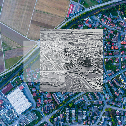
The CIPC dataset includes profit and non-profit organisations as registered with the Department of Trade and Industry. This dataset includes company’s name, registration number, operational status, directors, and geo-locations.
License: Restricted use
Data source: Department of Trade and Industry
Coverage: National
Feature: Attributes and/or Points
AfriGIS CAD/NAD Link
This layer is derived through the relationship between the AfriGIS Cadastre and AfriGIS National Address Database. This layer enables a user to map all associated addresses to a property.
License: Restricted use
Data source: AfriGIS CAD and AfriGIS NAD
Coverage: National
Feature: Attributes
AfriGIS Adjacent Suburbs
This layer is based on the AfriGIS suburb layer and includes the topological relationship between neighbouring suburbs.
License: Restricted use
Data source: AfriGIS Suburbs
Coverage: National
Feature: Attributes
AfriGIS Chief Directorate Surveys and Mapping (CDSM)
This dataset consists of water entities, rivers, railways, nature reserves and built-up areas.
License: Open use
Data source: DALRRD
Coverage: National
Feature: Lines and Polygons
SA links with L and R suburbs
This layer is derived through the relationship between the AfriGIS Street Centreline and AfriGIS Suburbs. The list indicates the relevant suburbs associated with each street segment.
License: Restricted use
Data source: AfriGIS Street Centrelines and AfriGIS Suburbs
Coverage: National
Feature: Attributes
Turn Penalties
This dataset indicates the expected time delay for routing purposes.
License: Restricted use
Data source: AfriGIS Street Centrelines
Coverage: National
Feature: Attributes

Weather
AfriGIS serves the South African Weather Service (SAWS) data feeds via the AfriGIS Weather API (Application Programming Interface), which includes measurements, forecasts, thunderstorms, lightning and weather alerts.
- Forecast
- Current and historical thunderstorms
- Current and historical lightning strikes
- Lightning report
- Radar
- Severe weather alerts
- CAP (Common Alert Protocol) notifications
License: Restricted use
Data source: SAWS
Coverage: National
Feature: Attributes
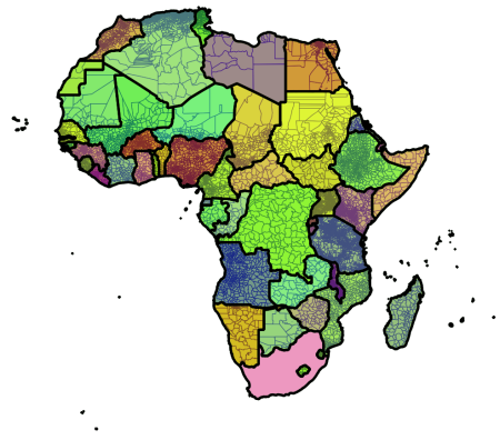
AfriGIS Africa Localities
This layer consists of the main Localities (also often referred to as Towns) for the continent of Africa. This layer was created using the Database of Global Administrative Areas (GADM), as well as Open Source information obtained from geonames.org
The layer has topology and follows the correct Administrative Level hierarchy, e.g. Eenhana, Omundaungilo, Ohangwena, Namibia.
License: Restricted
Data Source: GADM and geonames.org
Coverage: National
Feature: Polygon
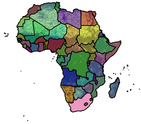
AfriGIS Africa Sub-Localities
This layer consists of the main Sub-Localities (also often referred to as Suburbs) for the continent of Africa. This layer was created using the Open Source information obtained from geonames.org and was transformed from a point feature to polygon. The layer includes over 490 000 Sub-Localities and includes small villages as well.
The layer has topology and follows the correct Administrative Level hierarchy, e.g. Ohamviimbi, Eenhana, Omundaungilo, Ohangwena, Namibia.
License: Restricted
Data Source: geonames.org
Coverage: National
Feature: Polygon
African countries covered under Localities and Sub-Localities
- Algeria
- Angola
- Benin
- Botswana
- Burkina Faso
- Burundi
- Cabo Verde
- Cameroun
- Central African Republic
- Chad
- Comoros
- Côte d’Ivoire
- Djibouti
- Egypt
- Equatorial Guinea
- Eritrea
- Eswatini
- Ethiopia
- Gabon
- Gambia
- Ghana
- Guinea
- Guinea-Bissau
- Kenya
- Lesotho
- Liberia
- Libya
- Madagascar
- Malawi
- Mali
- Mauritania
- Mauritius
- Morocco
- Mozambique
- Namibia
- Niger
- Nigeria
- Republic of Congo
- Rwanda
- São Tomé and Príncipe
- Senegal
- Seychelles
- Sierra Leone
- Somalia
- Sudan
- Tanzania
- The Democratic Republic of the Congo
- Togo
- Tunisia
- Uganda
- Zambia
- Zimbabwe
Professional Associations
We collaborate with
