
The Highs, the Lows, and What’s Ahead in 2025
Geospatial in Africa: The Highs, the Lows, and What’s Ahead in 2025 AfriGIS (Pretoria, South Africa – 06 October 2025) 2025 has been a year of both promise and challenge for Africa’s geospatial industry. Across the continent, location intelligence is helping cities grow smarter, businesses operate more efficiently, and communities access essential services. Yet while progress has been significant, the journey has not been without obstacles. Celebrating Milestones According to the 2025 United Nations Globa Geospatial Information Management (UN-GGIM) Africa report, African countries have made strides in embedding geospatial data into decision-making. Key achievements include: National Progress: Cameroon, Mali, Mozambique, and Rwanda have advanced action plans under the Integrated Geospatial Information Framework (IGIF), strengthening data infrastructures and aligning spatial data with sustainable development goals. Skills Development: Workshops and expert consultations are enhancing geospatial management skills, particularly for census work and development tracking. Technological Adoption: AI and digital twin technologies are beginning to reshape urban planning, enabling cities to anticipate challenges before they arise. Industry Growth: The Africa Geospatial Expo 2025 projected sector growth to US\$100 billion by 2030, highlighting its strategic importance across industries including healthcare, logistics, and finance. Challenges Along the Way Despite these milestones, the industry faces persistent challenges that slow momentum. These include: Skills Gaps: While GIS is included in university curricula, many business schools lack updated training on applying geospatial data for strategic decision-making. Limited Adoption: Many businesses remain unaware of the potential of geospatial tools, resulting in underutilisation across sectors. Data and Governance Issues: Outdated spatial data and fragmented policy frameworks continue to hinder the effective deployment of solutions. To address these challenges, stakeholders are leveraging public-private partnerships (PPPs), capacity-building initiatives, and policy reforms. AfriGIS has contributed by improving data quality and accessibility, promoting digital twin technology, and helping clients integrate geospatial intelligence into planning, compliance, and risk management. The Rise of Transformative Technologies Geospatial Technology One of the most exciting areas of growth is Geospatial technology. Driven by widespread smartphone penetration, improved connectivity, and regulatory requirements, Geospatial technology is reshaping industries across Africa. Specifically, it's being used in: Healthcare: to optimise access to clinics and improve outbreak response. Logistics: to enhance fleet management and delivery accuracy. Retail: retailers use it to target customers more effectively and to expand reach. Governments: apply it to map underserved areas and improve service delivery. AfriGIS APIs now support over 50 million searchable address combinations, enabling hyper-local insights that are transforming decision-making across sectors. Digital Twins: Planning Cities Before they are Built Digital twins (virtual replicas of cities and infrastructure) allow planners to simulate scenarios technology such as traffic flows, energy demand, and population growth. This capability makes infrastructure planning more resilient and efficient. Projects like the University of Pretoria’s Hatfield Digital Twin City demonstrate how technology can enhance urban management, citizen engagement, and service delivery. Contextual Insights for Sustainability Contextual insights integrate geospatial intelligence with real-world (environmental, demographic, and infrastructure) data to drive sustainable decision-making. Platforms like Resolve Water help businesses and municipalities manage water scarcity and risk, while supporting ESG compliance and equitable resource allocation. By turning raw data into actionable intelligence, contextual insights are advancing ESG goals, smart city development, and resilient infrastructure. Better Data, Better Decisions 2025 has also seen significant improvements in geospatial data quality and accessibility. AfriGIS has committed to: Quarterly Data Releases: ensuring datasets are up-to-date and validated. New Tools: APIs such as the Flood Hazard Index and platforms like Iris provide interactive, real-time access. Measurable Impact: Outcomes across sectors include reduced banking risk (40%), fewer fraudulent insurance claims (25%), increased retailer foot traffic (15%), and improved agricultural yields (18%). Looking Ahead: The Road for 2025 and Beyond Emerging technologies will continue to shape Africa’s geospatial landscape: AI-Driven Geospatial Intelligence: enabling predictive analytics and dynamic decision-making. High-Precision Mapping and LiDAR: Supporting urban planning and infrastructure audits. Spatial Computing and Digital Twins: Modelling cities and optimising resource allocation. ESG-Focused Platforms: Tools like Resolve Water helping businesses address climate and water risks. Collaboration as the Cornerstone Ultimately, the geospatial industry in Africa cannot reach its potential in isolation. Governments provide regulatory authority and reach, while private companies contribute agility, innovation, and investment. Public-private partnerships are essential for scaling solutions such as smart cities, climate adaptation, disaster response, and resilient infrastructure. The Path Forward Africa’s geospatial industry demonstrates that technology alone is not enough. Its true power lies in application; integrating data with context, building skills, fostering partnerships, and creating solutions that benefit communities. The highs of 2025 show what is possible when innovation meets purpose. The lows remind us there is more work to be done. With continued collaboration, investment, and innovation, Africa is poised to harness geospatial intelligence for smarter decisions, resilient communities, and a sustainable future.
Read More
Geospatial in Africa: The Highs, the Lows, and What’s Ahead in 2025
Geospatial in Africa: The Highs, the Lows, and What’s Ahead in 2025 2025 has been a year of progress and challenges for Africa’s geospatial industry. From embedding data into national decision-making to adopting transformative technologies such as AI, digital twins, and location-based services, the sector is reshaping urban planning, healthcare, logistics, and governance. According to the UN-GGIM Africa report, countries like Cameroon, Mali, Mozambique, and Rwanda are strengthening geospatial infrastructures under the IGIF, while initiatives like the Africa Geospatial Expo 2025 project growth to US$100 billion by 2030. AfriGIS has played a key role by improving data quality, expanding APIs to support over 50 million searchable addresses, and launching tools such as the Flood Hazard Index and Iris, driving measurable impacts across finance, agriculture, and retail. Yet, persistent challenges remain. Skills gaps in higher education, limited adoption of geospatial tools by businesses, and outdated or fragmented policy frameworks continue to slow progress. Stakeholders are addressing these issues through capacity-building, policy reforms, and public-private partnerships. Looking ahead, AI-driven intelligence, high-precision mapping, and ESG-focused platforms will shape the industry, but collaboration will be critical. Africa’s geospatial journey shows that innovation alone is not enough the power lies in application, partnerships, and using data to build smarter cities, resilient communities, and sustainable futures.
Read More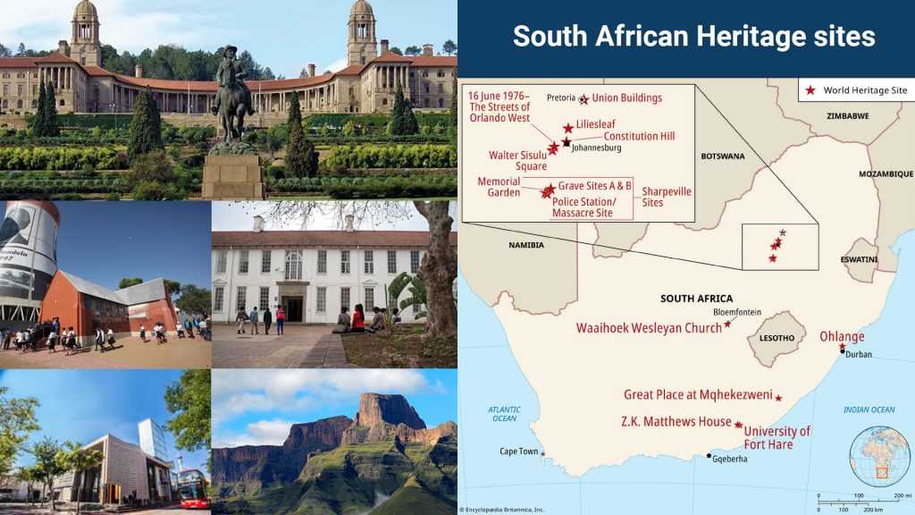
Preserving South Africa’s Heritage: AfriGIS and Geotripz Platform Highlight the Power of Geospatial Intelligence
In recognition of National Heritage Month, AfriGIS, in partnership with its Geotripz platform, is highlighting the critical role of geospatial intelligence in preserving South Africa’s cultural and natural heritage. By providing communities, government bodies and businesses with accurate location data, Geotripz helps ensure that heritage sites are recognised, protected and integrated into planning and investment decisions. Location data in South Africa reflects centuries of history, including patterns of dispossession and exclusion. Through the use of remote sensing, drones and contextual mapping, geospatial intelligence reveals communities historically left out of formal systems and makes previously invisible sites from ancestral lands to rural homesteads and community gathering points visible and permanent. “Maps are more than just coordinates they are instruments of inclusion and recognition,” says Kshetra Govindasamy, Director at Geotripz Spatial Solutions (AfriGIS). Clinton Heimann, Acting Director-General for DLRRD and Co-Chair for UN-GGIM, adds: “If a site is not documented, it is at risk of being erased by development. Geospatial intelligence makes heritage visible and permanent in the systems that guide land use and investment.” Beyond safeguarding landmarks, the Geotripz platform visualises intangible and natural wealth by overlaying cultural landmarks alongside ecological sites to provide a comprehensive view of the heritage landscape. This contextual insight enables sustainable development, informs conservation strategies and supports ESG and carbon-friendly initiatives, while empowering communities to see and interact with the heritage around them. “When people see their heritage respected in official systems, it validates their dignity. That recognition builds trust, and trust is what binds a society together,” says Heimann.
Read More
Restoring Trust in Municipalities Through GIS-Enabled Asset Management Systems
Restoring Trust in Municipalities Through GIS-Enabled Asset Management Systems Recently, President Cyril Ramaphosa acknowledged at the ANC’s councillor roll call in Soweto that DA-led municipalities often outperform those run by the ANC, urging councillors to learn from better-performing municipalities. This highlights the urgent need for South African municipalities to restore public trust by improving service delivery, enhancing accountability, and operating with transparency, writes Rochelle Mountany, CEO of AfriGIS. Many municipalities struggle due to siloed, incomplete, or outdated data leading to challenges in revenue collection, waste management, and service allocation. Informal developments, unregistered properties, and sectional schemes frequently go unrecorded, creating blind spots that weaken efficiency and accountability. The solution lies in a GIS-enabled asset management system: a centralised data platform accessible across all municipal departments. By integrating billing, legal, water, and infrastructure information into one source of truth, municipalities can track every household, service request, and asset in real-time. This ensures accurate allocation of resources, transparent workflows, and improved accountability. Councillors and managers can verify property ownership, monitor service coverage, track incident response times, and even reduce corruption through verified contractor management. The ability to overlay critical geospatial data such as land use, flood-prone areas, and cadastre records further strengthens decision-making for planning, emergency response, and development approvals.
Read More
How Geospatial Insights Can Transform Service Delivery Planning and Analysis in South Africa
South Africa’s property development market is full of potential but making the right decisions about where and what to build requires more than just identifying available land. At AfriGIS, we help developers make smarter, data-driven decisions by combining geospatial science with powerful tools like Trade Area Analysis. Our approach goes beyond traditional land evaluation, offering a comprehensive understanding of the market landscape everything from rental trends and income levels to transport links, infrastructure, and environmental risks. With demand for multifamily housing on the rise and urban growth shifting rapidly, developers can no longer rely on static reports or surface-level insights. AfriGIS offers real-time, dynamic data that evolves with the market, allowing for informed decision-making throughout the entire development lifecycle from initial land acquisition to ongoing operational strategy. Whether you're developing luxury apartments, student housing, or affordable family homes, we provide the insights needed to align your investment with actual market demand. Our tools offer a clear view of the bigger picture, helping developers assess potential return on investment, forecast demand, reduce risk, and optimise each development’s success. With features like the Neighbourhood Lifestyle Index, developers gain a deep understanding of who will live in their developments their income, preferences, and lifestyle needs enabling more targeted and profitable projects. At AfriGIS, we help you future-proof your property investments by offering a smarter way to see and understand the spaces you build in. Let data guide your decisions and unlock long-term growth.
Read More
AfriGIS Recognised as a Core Contributor to GeoServer
South Africa’s property development market is full of potential but making the right decisions about where and what to build requires more than just identifying available land. At AfriGIS, we help developers make smarter, data-driven decisions by combining geospatial science with powerful tools like Trade Area Analysis. Our approach goes beyond traditional land evaluation, offering a comprehensive understanding of the market landscape everything from rental trends and income levels to transport links, infrastructure, and environmental risks. With demand for multifamily housing on the rise and urban growth shifting rapidly, developers can no longer rely on static reports or surface-level insights. AfriGIS offers real-time, dynamic data that evolves with the market, allowing for informed decision-making throughout the entire development lifecycle from initial land acquisition to ongoing operational strategy. Whether you're developing luxury apartments, student housing, or affordable family homes, we provide the insights needed to align your investment with actual market demand. Our tools offer a clear view of the bigger picture, helping developers assess potential return on investment, forecast demand, reduce risk, and optimise each development’s success. With features like the Neighbourhood Lifestyle Index, developers gain a deep understanding of who will live in their developments their income, preferences, and lifestyle needs enabling more targeted and profitable projects. At AfriGIS, we help you future-proof your property investments by offering a smarter way to see and understand the spaces you build in. Let data guide your decisions and unlock long-term growth.
Read More
A Call for Change in South Africa’s Tech and Geospatial Sectors
South Africa’s property development market is full of potential but making the right decisions about where and what to build requires more than just identifying available land. At AfriGIS, we help developers make smarter, data-driven decisions by combining geospatial science with powerful tools like Trade Area Analysis. Our approach goes beyond traditional land evaluation, offering a comprehensive understanding of the market landscape everything from rental trends and income levels to transport links, infrastructure, and environmental risks. With demand for multifamily housing on the rise and urban growth shifting rapidly, developers can no longer rely on static reports or surface-level insights. AfriGIS offers real-time, dynamic data that evolves with the market, allowing for informed decision-making throughout the entire development lifecycle from initial land acquisition to ongoing operational strategy. Whether you're developing luxury apartments, student housing, or affordable family homes, we provide the insights needed to align your investment with actual market demand. Our tools offer a clear view of the bigger picture, helping developers assess potential return on investment, forecast demand, reduce risk, and optimise each development’s success. With features like the Neighbourhood Lifestyle Index, developers gain a deep understanding of who will live in their developments their income, preferences, and lifestyle needs enabling more targeted and profitable projects. At AfriGIS, we help you future-proof your property investments by offering a smarter way to see and understand the spaces you build in. Let data guide your decisions and unlock long-term growth.
Read More
Driving Smarter Property Development Decisions with Geospatial Insights
South Africa’s property development market is full of potential but making the right decisions about where and what to build requires more than just identifying available land. At AfriGIS, we help developers make smarter, data-driven decisions by combining geospatial science with powerful tools like Trade Area Analysis. Our approach goes beyond traditional land evaluation, offering a comprehensive understanding of the market landscape everything from rental trends and income levels to transport links, infrastructure, and environmental risks. With demand for multifamily housing on the rise and urban growth shifting rapidly, developers can no longer rely on static reports or surface-level insights. AfriGIS offers real-time, dynamic data that evolves with the market, allowing for informed decision-making throughout the entire development lifecycle from initial land acquisition to ongoing operational strategy. Whether you're developing luxury apartments, student housing, or affordable family homes, we provide the insights needed to align your investment with actual market demand. Our tools offer a clear view of the bigger picture, helping developers assess potential return on investment, forecast demand, reduce risk, and optimise each development’s success. With features like the Neighbourhood Lifestyle Index, developers gain a deep understanding of who will live in their developments their income, preferences, and lifestyle needs enabling more targeted and profitable projects. At AfriGIS, we help you future-proof your property investments by offering a smarter way to see and understand the spaces you build in. Let data guide your decisions and unlock long-term growth.
Read More
Six Ways to Maximise Your Retail Store’s Success with Trade Area Analysis
Six Ways to Maximise Your Retail Store’s Success with Trade Area Analysis AfriGIS (Pretoria, South Africa – 16 July 2025) Why Location Strategy Is Critical in Retail In the fast-paced retail industry, the key to growth lies in choosing the right locations. Retailers must not only consider foot traffic but also the purchasing power of the surrounding population, consumer characteristics, and ever-changing market dynamics. A poor location decision can lead to missed opportunities and underperforming stores. Cost of shop fitting and wasted costs associated with signing long term lease agreements make this even more crucial. This is where Trade Area Analysis comes into play. For any retail business looking to roll out their first (or fifty-first store), Trade Area Analysis empowers them to make smarter, data-driven decisions. By leveraging this process, retailers can strategically position their stores in locations where the surrounding population has strong purchasing power, competitor locations are known, which significantly increasing the likelihood of high sales performance. The question then isn’t whether Trade Area Analysis is worth the expense, but whether your business can afford not to invest in it Here are six reasons why: 1. Optimising Store Placement Trade Area Analysis uses demographic and geographic data to identify locations with high potential for success, based on factors like population density, income, accessibility, target demographic, competitor locations, and other factors, reducing the risk of opening in underperforming areas. 2. Understanding Customer Demographics Every market is different, and consumer preferences vary by location. Trade Area Analysis helps businesses understand the makeup of their customer base, including age, income, lifestyle, and buying habits. By understanding these factors, retailers can tailor their offerings to meet the needs of local customers, ensuring higher engagement and stronger sales. 3. Improving Marketing Strategies With Trade Area Analysis, retailers can define their target audience based on location-specific data. By understanding the customer demographics within their trade area, businesses can create more targeted marketing campaigns that resonate with local consumers, increasing conversion rates and customer loyalty. 4. Forecasting Demand Predict customer demand by analysing movement patterns, seasonal trends, weather information and demographic shifts. This predictive insight allows businesses to optimise their inventory management, ensuring they’re always stocked with what their customers want, when they want it. 5. Enhancing Operational Efficiency By understanding where customers are located and how they behave, retailers can optimise their supply chain, staffing, and operational resources to ensure they meet demand without overextending their resources. Products can therefore be aligned with target demographics. This leads to cost savings and more efficient day-to-day operations. 6. Mitigating Risks Identify potential risks before they become problems. Whether it's recognising an emerging competitor in a particular area or understanding the impact of infrastructural changes like new public transport routes, businesses can take proactive measures to minimise risk and protect their investment. In today’s competitive retail environment, relying on gut feel or outdated sales data is no longer enough. AfriGIS Trade Area Analysis offers a smarter, more effective way to plan and execute retail rollouts, making it a critical tool for businesses aiming to thrive. The opportunity cost of not investing in Trade Area Analysis: For retailers, choosing the right location isn’t just about visibility—it’s about strategically placing stores in areas where the right customers, with the right purchasing power, are. Trade Area Analysis offers a data-driven approach to ensure that businesses make informed decisions, increase sales performance, and optimise their operations for sustainable growth. WHERE are my customers at the moment? WHERE are my competitors? WHERE should I place new outlets? Learn more about our Trade Area Analysis Location Strategy Solution and schedule a free consultation Speak to an expert
Read More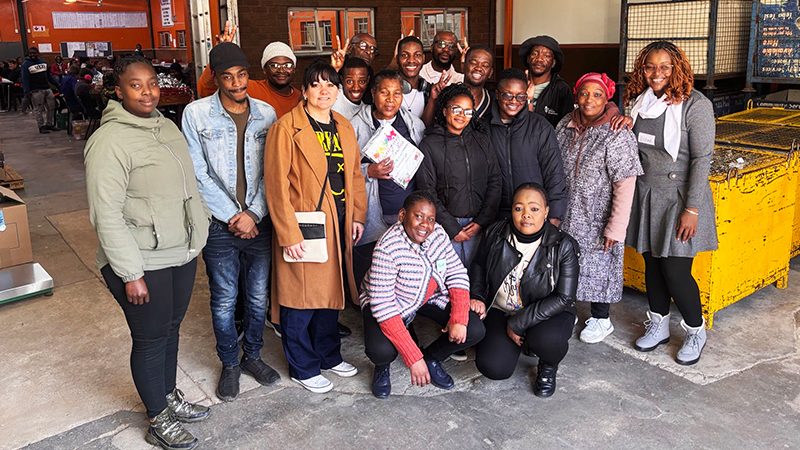
Empowerment Through Partnership: AfriGIS and Employment Solutions for People with Disabilities
At AfriGIS, we believe that data has the power to transform the world and that power should be shared. Since 2016, we’ve partnered with Employment Solutions, a Tshwane-based nonprofit that creates work opportunities for persons with disabilities. Together, we’re building more than maps we Are building inclusive, empowered communities. What started with basic packaging and manual tasks has evolved into something extraordinary. Today, individuals at Employment Solutions are trained to interpret satellite imagery and update critical street centreline data for our mapping systems the very data that enables GPS navigation, logistics planning, and route optimisation across Southern Africa. These are real jobs with real impact. Currently, the team is focused on digitising Mozambique’s road network a meticulous, high-value task carried out with precision and pride. Through hands-on training tailored to meet the needs of deaf workers and those with limited formal education, Employment Solutions has built a thriving model of supported employment in the digital economy. The collaboration is more than Corporate Social Responsibility it’s a vision for a future where ability is recognised, respected, and rewarded.
Read More