What rapid-response spatial intelligence knew before the Garden Route flooded again
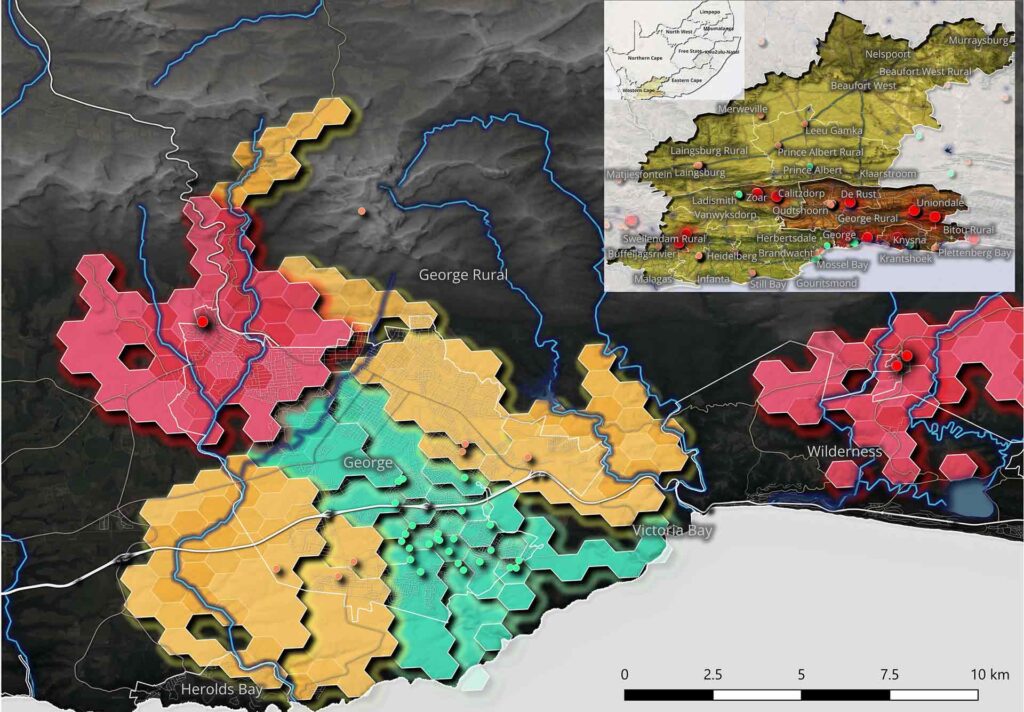
What rapid-response spatial intelligence knew before the Garden Route flooded again South Africa's Garden Route was hit by two cutoff low storms within a month, the second in early June 2026 bringing up to 200mm of rain across an already-satur…South Africa's Garden Route was hit by two cutoff low storms within a month, the second in early June 2026 bringing up to 200mm of rain across an already-saturated region with dams at full capacity, May's temporary road repairs still in place, and the N1 at Leeu Gamka eventually closing. Before that second storm peaked, AfriGIS had already used just four rapidly integrated spatial data layers roads, rivers, informal settlement locations, and storm warning data to identify 22 of the Garden Route's 209 informal settlements at extreme risk of losing all physical access, with Kannaland and George carrying 16 of those, enabling disaster management teams to pre-position resources and plan evacuation routes before conditions peaked. The deeper argument is that the same four-layer foundation becomes substantially more powerful with each additional dataset layered onto it: add deeds and cadastre data and an insurer can move to parcel-level flood underwriting; add CIPC business data and you can quantify revenue disruption, not just building damage; layer in infrastructure assets and Transnet, Sanral, and Eskom can each see where their balance-sheet exposure becomes critical. AfriGIS positions this building-block quality backed by 28 years of authoritative, never-crowdsourced verified data as the foundation for what national-scale spatial preparedness could deliver as SA's rainfall season runs through November.
Read More
Why static property data is costing South African short-term insurers their margins
Why static property data is costing South African short-term insurers their margins South Africa's short-term insurers are pricing property risk against municipal valuation rolls built for tax collection, updated on multi-year cycles, and reflecting a version of the country that no longer exists in many areas. As semigration accelerates to secondary hubs and infrastructure struggles to keep pace, a blocked stormwater drain or outdated flood wall can transform a historically low-risk property into an active hazard overnight. Insurers relying on lagging municipal records will miss these shifts entirely, and the exposure only becomes visible after a severe weather event. The solution is exact geocoding. By pinning property records to precise geographic coordinates, underwriters can overlay real-time spatial layers covering flood lines, fire hazards, weather patterns, and infrastructure constraints, enabling street-by-street risk pricing rather than broad municipal approximations. The same intelligence extends to operations: geofenced hail alerts warn policyholders before damage occurs, and satellite imagery cross-referenced with deeds data automates agricultural claims validation. Insurers who embed location intelligence into their workflows move from reactive loss management to proactive, precision underwriting.
Read More
Combatting synthetic identity fraud with physical location intelligence in KYC
Combatting synthetic identity fraud with physical location intelligence in KYC Financial criminals are skilled at fabricating convincing paper and digital trails, but what they cannot replicate is physical reality. Every legitimate consumer and business leaves a spatial fingerprint over time, and building years of realistic spatial behaviour for a fake identity is cost-prohibitive. By cross-referencing deeds registry data, which AfriGIS updates monthly, with CIPC company registration records updated weekly, lenders can automatically surface red flags before any transaction occurs. A registered headquarters mapping to a vacant field, or a business activity conflicting with a property's zoning, becomes visible through automated reconciliation of physical reality against administrative records. It is cheap to create a digital record, but expensive to put a physical building on a piece of land. Generative AI has made synthetic personas easier to construct than ever, but spatial reality remains difficult to fake. By anchoring digital identities to verified physical addresses, organisations establish an objective layer of truth that shifts fraud prevention from reactive investigation to proactive, real-time defence.
Read More
Real-time deeds data maps the next phase of South Africa’s economic growth
Real-time deeds data maps the next phase of South Africa’s economic growth By the time semigration or urbanisation trends appear in a census or annual report, the first-mover window has closed. The organisations that get ahead of market shifts are those reading faster, more granular signals. In a market where secondary cities like George, Nelspruit, and Hilton shift demand every quarter, relying on outdated benchmarks represents a material risk for any organisation making multi-million rand investment, lending, or site-selection decisions. Legally verified deeds data, enriched with spatial intelligence and updated monthly, provides exactly that edge. Unlike survey-based indicators, deeds records represent financial commitments already made: buyers who have secured finance and signed transfer documents. When layered with cadastre information, urban extents, and environmental risk data, a raw ownership record becomes a live proxy for shifting affluence rather than just another row in a database. The applications span the enterprise. Banks improve loan-to-value accuracy and fraud detection by verifying a property's physical existence and history. Insurers enable hyperlocal underwriting tied to specific asset locations. Retailers and telecoms use property values as affordability proxies to guide expansion decisions. Property developers assess land assembly history before committing capital. AfriGIS transforms Surveyor General registers into this kind of decision intelligence by adding the spatial layers that turn a coordinate into real insight, and the gap between organisations using real-time property intelligence and those relying on historical benchmarks is widening fast.
Read More
Despite 32 years of freedom, millions of South Africans are still invisible
Despite 32 years of freedom, millions of South Africans are still invisible Thirty years after South Africa's democratic promise of equal access to services and opportunity, millions of citizens are being turned away from bank accounts, insurance, municipal services, and emergency response not because they lack addresses, but because the systems processing those addresses were never designed to recognise them. South Africa has 14 recognised address types, from formal suburban streets to informal settlement identifiers, rural farm addresses, and sectional title schemes. Yet most institutions only look at one or two. When a system expects a street name and number and receives something different, it doesn't recognise a different address class; it concludes the address is wrong. Repeated at scale across every sector, that rejection becomes a form of structural exclusion that hides behind process. The deeper problem, as AfriGIS geospatial scientist Marna Roos explains, is a misplaced assumption about what an address should look like. Areas have been classified as undeveloped simply because the data was incomplete, leaving residents invisible to service allocation decisions. The more complete the address data, the more democratic the decision-making. AfriGIS holds verified data across all 14 address types, and is calling on government, financial institutions, and the private sector to move beyond single-layer address systems. An organisation operating on one out of 14 address classes isn't making informed decisions; it is making assumptions that consistently disadvantage the same communities marginalised before 1994.
Read More
SA’s multiple ‘acceptable’ versions of addresses are a threat to banking KYC compliance
SA’s multiple ‘acceptable’ versions of addresses are a threat to banking KYC compliance South Africa has roughly 10 million unique physical locations, but over 50 million valid aliases for those same places, suburban street names, erf numbers, sectional title references, farm portion descriptions, all legitimate, all inconsistently captured. When different departments onboard, underwrite, and collect using different address variants, the organisation loses its single source of truth. A customer can exist as multiple entities within the same system, creating gaps in risk modelling and, more critically, openings for illicit activity to go undetected. The gap between an address being "good enough for delivery" and "complete for compliance" is precisely where KYC and FICA exposure lives. The fix is moving from simple coordinates to verified, structured address intelligence. AfriGIS's National Address Dictionary (NAD) reconciles over 14 distinct South African address types into a single, ISO20022 compliant schema, linking every alias to one spatial reference point. This allows financial organisations to standardise data across silos, enrich addresses with demographic and environmental context, and detect mismatches between declared information and physical reality. In a regulatory environment where precision is a global mandate, mastering South Africa's address complexity isn't just a compliance exercise. It's a foundation for understanding customers and the contexts in which they do business.
Read More
Shuttered stores and the streets delivery drivers give up on: The multibillion-rand cost of failing maps
Shuttered stores and the streets delivery drivers give up on: The multibillion-rand cost of failing maps A delivery driver circles a nameless corner in a Gauteng settlement while a utility planner stares at a transmission blueprint that doesn't match the ground beneath it. Both are casualties of the same problem: location data treated as simple coordinates rather than contextual intelligence. The cost is measurable, a major national retailer shuttered roughly 20 stores last year because trade mapping failed to align the full set of variables a site requires: the right taxi route, a grocery anchor in sightline, the correct income demographic, a calculated distance from competitors. Miss one factor and a multimillion-rand investment becomes a shuttered store. The same spatial friction plays out in last-mile delivery, where a failed drop compounds into a return, and in infrastructure planning, where an inaccurate settlement boundary can close the window on a servitude before the first line is drawn. The solution isn't more data it's verified, contextual intelligence. A South African postal code can contain 49 suburbs and dozens of distinct economic realities, which is precisely where global platforms fail and where local precision matters. AfriGIS has spent 28 years building that precision: a National Address Dictionary of over 53 million searchable addresses including informal settlements and complex sectional titles aligned with UN-GGIM principles and accessible through flexible, open-standard APIs. The shift the industry needs is from "price per data point" to "value per successful decision." Knowing exactly where we are standing is the only way to know exactly where we are going.
Read More
Why water risk is the next boardroom accountability test
From Greylist to Greyed Out: The Hidden Risk in South Africa’s Payment Infrastructure South Africa faces the risk of being excluded from the global SWIFT payments network if it fails to adopt the ISO 20022 messaging standard by November 2026. The new system replaces older unstructured payment messages with structured digital formats that require precise data fields, including properly formatted addresses. However, South Africa has complex and inconsistent address data due to factors such as informal settlements, farm portions, and broad postal codes that cover multiple areas. This makes it difficult for international banking systems to interpret the data, which could result in cross-border payments being rejected even if funds are available. Improving data quality, standardising address information, and consolidating data from multiple sources will be necessary to ensure the country remains compliant and connected to global financial systems.
Read More
Avoiding the global payment ‘grey out’ and why you are a step ahead
From Greylist to Greyed Out: The Hidden Risk in South Africa’s Payment Infrastructure South Africa faces the risk of being excluded from the global SWIFT payments network if it fails to adopt the ISO 20022 messaging standard by November 2026. The new system replaces older unstructured payment messages with structured digital formats that require precise data fields, including properly formatted addresses. However, South Africa has complex and inconsistent address data due to factors such as informal settlements, farm portions, and broad postal codes that cover multiple areas. This makes it difficult for international banking systems to interpret the data, which could result in cross-border payments being rejected even if funds are available. Improving data quality, standardising address information, and consolidating data from multiple sources will be necessary to ensure the country remains compliant and connected to global financial systems.
Read More
AfriGIS Announcement: Is your data ready for the new ISO 20022 Global standard?
Structured Addresses, Smarter Systems: How GIS Empowers ISO 20022 Compliance and Beyond The global migration to ISO 20022 represents a major evolution in financial data standards, with structured address data becoming compulsory for all cross-border payments from 1 November 2025 to 1 November 2026. This shift is designed to strengthen accuracy, compliance, and transparency across international financial systems. For South Africa, however, the transition introduces unique complexities: multiple postal code variations, informal settlements without street names, and diverse address formats that do not easily fit a rigid global template. Without proper data structuring, institutions risk failed validations, delayed payments, and regulatory penalties. AfriGIS brings more than 20 years of geospatial intelligence expertise to this challenge. Our address database built from cadastral, postal, and satellite data allows us to cleanse, validate and structure address information to meet ISO 20022 standards while preserving critical local context. Through configurable APIs and advanced contextual intelligence, we help banks, fintechs, and corporates achieve seamless compliance and unlock broader benefits, including enhanced risk analysis, accurate geocoding, improved onboarding processes, and a reliable single source of truth for address data across the enterprise.
Read More