GIS

Geospatial data lays the foundation of tomorrow's smart cities

Geospatial data is the cornerstone of sustainable smart city initiatives. As cities face increasing pressures from urbanisation, the integration of data-driven technologies into urban planning is vital. Geospatial data enables cities to map, analyse, and optimise every aspect of infrastructure, from energy grids and transport networks to utilities and environmental features.

Read More

AfriGIS welcomes new CEO to spearhead innovation in geoscience

AfriGIS, a leading geoscience data firm based in South Africa, has appointed Rochelle Mountany as Chief Executive Officer effective September 2024.

Read More

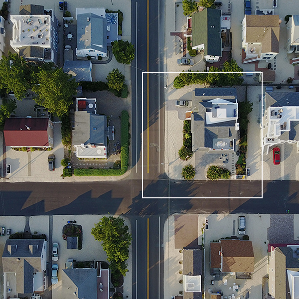
How GIS is transforming municipal property management

GIS is transforming municipal property management. GIS technology provides accurate, up-to-date data, helping local governments make informed decisions. From identifying state-owned land and tracking property changes to improving service delivery and infrastructure planning, GIS is essential. It addresses challenges like uncollected revenue and missing title deeds, ensuring efficiency and accountability.

Read More

Why spatial data accuracy matters

The strategic importance of data quality in a data-driven world Organisations across various industries rely on high-quality spatial data to make informed decisions that enhance efficiency and drive innovation. Learn why data quality is essential, how different industries prioritise data standards, the role of technologies like AI and machine learning in maintaining data integrity, and strategies for ensuring reliable data and the profound impact it can have on business success.

Read More

Staying ahead of unpredictable weather conditions

Staying ahead of unpredictable weather conditions By integrating weather-based data with policy information, AfriGIS allows MiWay to proactively inform clients about looming weather events, such as heavy rain, hailstorms, and lightning strikes. This protects clients’ assets and helps to prevent fraud, while also supporting MiWay's goals to reduce operational costs, meet regulatory standards, and promote sustainable business practices amid changing weather patterns.

Read More

Beyond borders – AfriGIS develops verified geospatial data for Africa

AfriGIS develops unique geospatial dataset for African continent. AfriGIS's verified and validated datasets cover the African continent's vast and varied administrative boundaries, enhancing strategic decision-making in sectors such as retail, logistics, and governance. Gain access to detailed polygon datasets and extensive data overlays through our APIs, which include everything from street centrelines to demographic insights. Unlock the potential of your African business with accurate mapping and data-driven insights from AfriGIS.

Read More

AfriGIS’s Peter Smythe appointed to GeoServer Project Steering Committee

We are proud to announce that Peter Smythe, Senior Systems Analyst at AfriGIS, has been appointed to the GeoServer Project Steering Committee. This role recognises his significant contributions to the GeoServer community and his dedication to advancing open-source GIS technologies. Join us in congratulating Peter on this prestigious appointment!

Read More

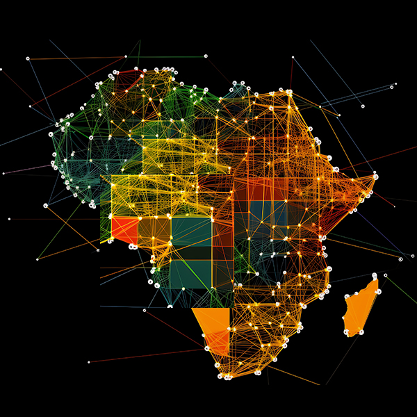
Addressing Geoscience Challenges in Africa

With 27 years of experience, AfriGIS offers unparalleled insights into the African market, backed by a commitment to providing reliable, accurate data.

Read More

Location intelligence is the secret weapon of data-driven banking.

By integrating geographic data with customer insights, AfriGIS enables banks to understand and serve their customers more effectively. This helps identify underserved areas, allowing for targeted and relevant financial services. Our technology breaks down traditional barriers and ensures compliance, paving the way for personalised banking experiences.

Read More

Steering FMCG growth with GIS insights

Transforming FMCG sales with geospatial insights from AfriGIS In the competitive landscape of South Africa's FMCG market, a prominent national FMCG company partnered with AfriGIS to redefine its approach to sales and marketing. Leveraging the power of Geographic Information Systems (GIS) and the spatial data AfriGIS offers, this collaboration has set new standards in strategic decision-making and market penetration.

Read More

Embracing the Power of Geospatial Technology.

The AfriGIS Data and Spatial Workshop, held on November 22, 2023, at the Premier Hotel in Midrand, Johannesburg, marked a significant event in the GIS community. Themed “Embracing the Power of Geospatial Technology: Becoming Future-Ready,” the workshop brought together experts and enthusiasts in the field of Geographic Information Systems (GIS) to explore the ever-evolving landscape of geospatial technology and its transformative impact across multiple industries.

Read More

Embrace AI but be aware of the data pitfalls for the unwary

While AI has made remarkable progress in recent years and offers numerous benefits across industries, it is essential to be aware of the potential risks associated with its adoption. Unvalidated data sources, manipulated data, copyright infringement, loss of data control, and undifferentiated business outcomes are among the challenges to consider.

Read More

Thank you – yes, you!

Why are maps more potent today than ever and very different from the ones we first encountered stored in rolls for Geography lessons at school? Brian Civin has been around considerably longer than AfriGIS’ 25 years (this May). And he has a key insight into why maps are a (not-so-secret) powerful new business enabler.

Read More

AfriGIS turns 25

This May we turn 25 years old, at a time when the industry's fortunes look set to soar.

Read More

8 ways we make location intelligence better

Why should you care what geospatial information and geographic information systems are?

Read More

How you can access fast financial services growth too

We don’t always need more data. Sometimes we need better data that’s more relevant so we can find new opportunities, new ways to serve customers, new ways to help the burgeoning teams of data scientists, product managers, marketers, and all the other people dedicated to turning things around and staying the path.

Read More

Locating the Future with the Power and Potential of GIS

It is our belief that the power of GIS lies in its ability to transform organisational outcomes. That location-based intelligence solutions enhances customer satisfaction, grows revenue streams, streamlines operational performance, and ensures sustained profitability – regardless of the business sector.

Read More

University of Pretoria: Faculty of Natural and Agricultural Science Department of Geography, Geoinformatics and Meteorology Advisory Committee meeting

The Advisory Committee aims to liaise in a formal and structured way and on a regular basis with all sectors of the industry. This assists the department to develop and maintain a programme that meets the requirements of the industry and the workplace.

Read More

South Africa’s new smart cities: a roadmap for transforming all our cities

We are on the edge of a geospatial transformation in South Africa. GIS is the ultimate ‘connector of dots’, and is the key to unlocking the true value and potential of the smart technology that’s required to digitise urban ecosystems and make smarter cities a reality. GIS has the power to unlock rich new insights, power better decision-making, and act as a catalyst for new products and services across all industry sectors. It has the potential to add billions to our economy, improve the quality of life and wellbeing of our communities, and help protect our planet.

Read More

Meet AfriGIS Iris: A Window into the Inner World of Our Solutions

AfriGIS Iris was developed by our team of geospatial scientists with the explicit aim of taking you on an interactive journey to demonstrate the capabilities of AfriGIS Solutions.

Read More

The Power of GIS in Action: Hot Spot Mapping

At AfriGIS we realise that it is sometimes hard to comprehend the extent of what it is that our industry is capable of. A great example of the power and social impact of geospatial information systems (GIS) in action is Hot Spot Mapping.

Read More

AfriGIS assists Financial Institutions to SAVE TIME

Submit a single or multiple coordinates in BULK and get immediate answers. AfriGIS assists Financial Institutions to SAVE TIME with AfriGIS Enterprise Reverse Geocoding for fixed and moveable assets.

Read More

A quick intro to geospatial standards and why they matter to you

There is a buzzword every year. We seem to have our pick of three letter acronyms and catch phrases in boardrooms in the same way we have top 20 music hits on the radio. “Geographical standards” have become one of those flavoured phrases.

Read More

The future of Big Data

The first quarter AfriGIS Data and Spatial Workshop took place on 3 April 2019 at the Bytes Technology Conference Centre in Gauteng, bringing together business and data experts to further explore the previous year’s theme on Big Data management, systems, procedures and analytics. This year, the focus in on the future of Big Data, and new ways of sustaining it...

Read More

How Location Insights answers the WHERE questions of your business

How Location Insights answers the WHERE questions of your business Dec 7 2017The fourth quarter AfriGIS Data and Spatial Workshop took place at the Bytes Conference Centre in Midrand on 6 December 2017. A lot of our longstanding and new clients from across Gauteng attended the event where changes and additions to the AfriGIS Dataset and Spatial Environment...

Read More

Standardisation a main driving force

Standardisation a main driving force Dec 6 2017 The 45th Plenary week of ISO/TC211 was held in Wellington, New Zealand, during the last week of November 2017. Like a symphony, it takes a lot of people working together to develop a standard. ISO’s role is similar to that of a conductor, while the orchestra is made up of independent technical experts nominated by our members...

Read More

3 September 2013

AfriGIS exhibiting at 14th Annual ST Group User Conference Bytes Conference Centre, Midrand

Read More
We use cookies to give you the best experience.